When General Wade came to Scotland and commenced his work of road construction in 1725 as part of the Government’s scheme to enforce the Disarming Act in the Highlands, no road had been made north of Stirling; tracks there were, but no proper roads.
Prior to this time pack horses and ‘carns’ or sledges were used; wheeled vehicles or bridges were unknown in this part of the country. It has been said that the vehicle in which he travelled when surveying the ground was a heavy coach the like of which had never been seen in these parts and was a source of wonder and even awe to the Highlanders. When it is recalled that the Romans reported that some of the Picts and Gaels fought in wheeled chariots (wheels of such chariots have since been dug up), it is strange to think that their use should appear to have been forgotten in the Highlands for centuries.
In the Highland Roads and Bridges Reports, 1828, it is stated that “the usual practice in roads constructed by Wade was to excavate all the earth and turf until gravel appeared, when the road surface was then dressed and formed on it, and the excavation and rubbish being thrown on either side, the road, (generally not more than twelve feet wide) was left in the form of a ditch. No great inconvenience was occasioned by this mode of construction in summer, but in winter it evidently formed a complete receptacle for snow.” A good place to see ditch-like roads is to the west of Amulree Hall.
In passing it may be noted that the cost of the roads over the whole system averaged out at about £70 per mile and that when they were first constructed, no bridges were built; fords were used first, followed by wooden bridges, then by stone.
Wade’s road and the three bridges which come within the scope of this account formed part of his great Crieff to Dalnacardoch road, which ran from Pitilie to the Square in Aberfeldy. From the Square it followed the line of the present main street and crossed the Paldie Burn, as the Moness Burn was called at that time, by a bridge, since widened by about 5 feet, which when examined from below still shows the original arch; the newer part, downstream, is carried on metal girders. The road then continues a little way along the line of the present Bank Street, between the hamlets of Over and Nether Miltons of Aberfeldybeg, before turning northward to reach the river in a slightly more direct line than that of Taybridge Road.
In Nether Milton there was a meal mill on a site near that of the present Water Mill bookshop and café, and close by there was also a lint mill. Both these mills were driven by the same water supply, fed from a dam which lay to the south near the eight or ten house constituting Over Milton.
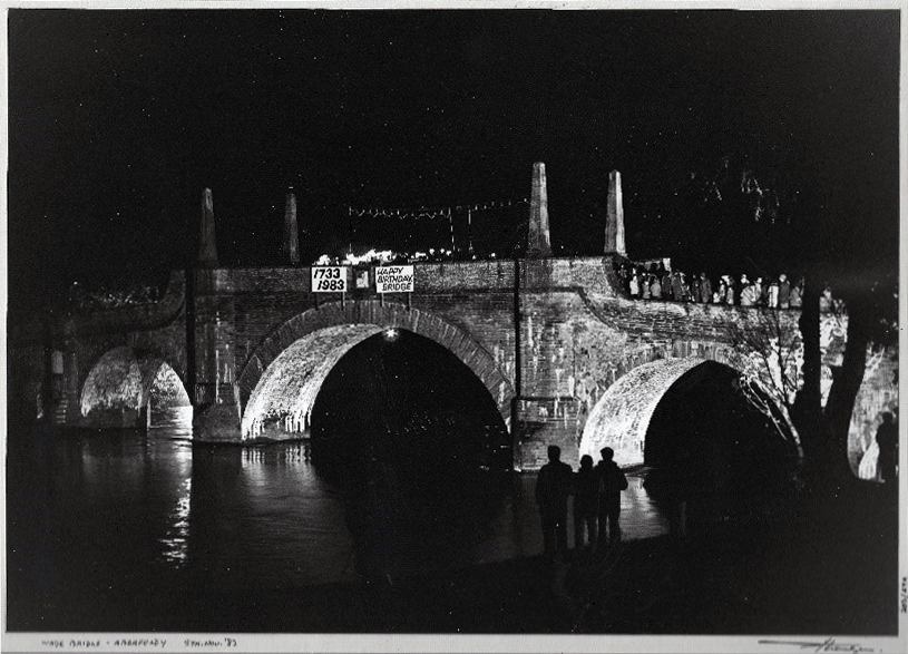
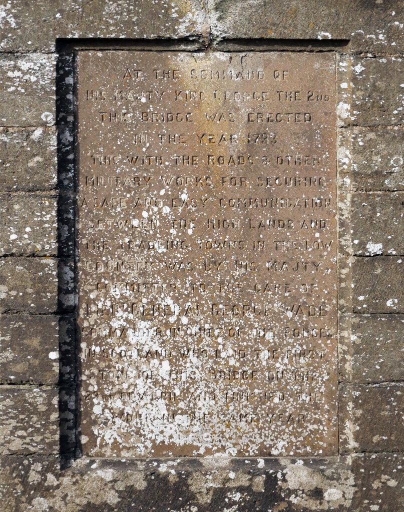
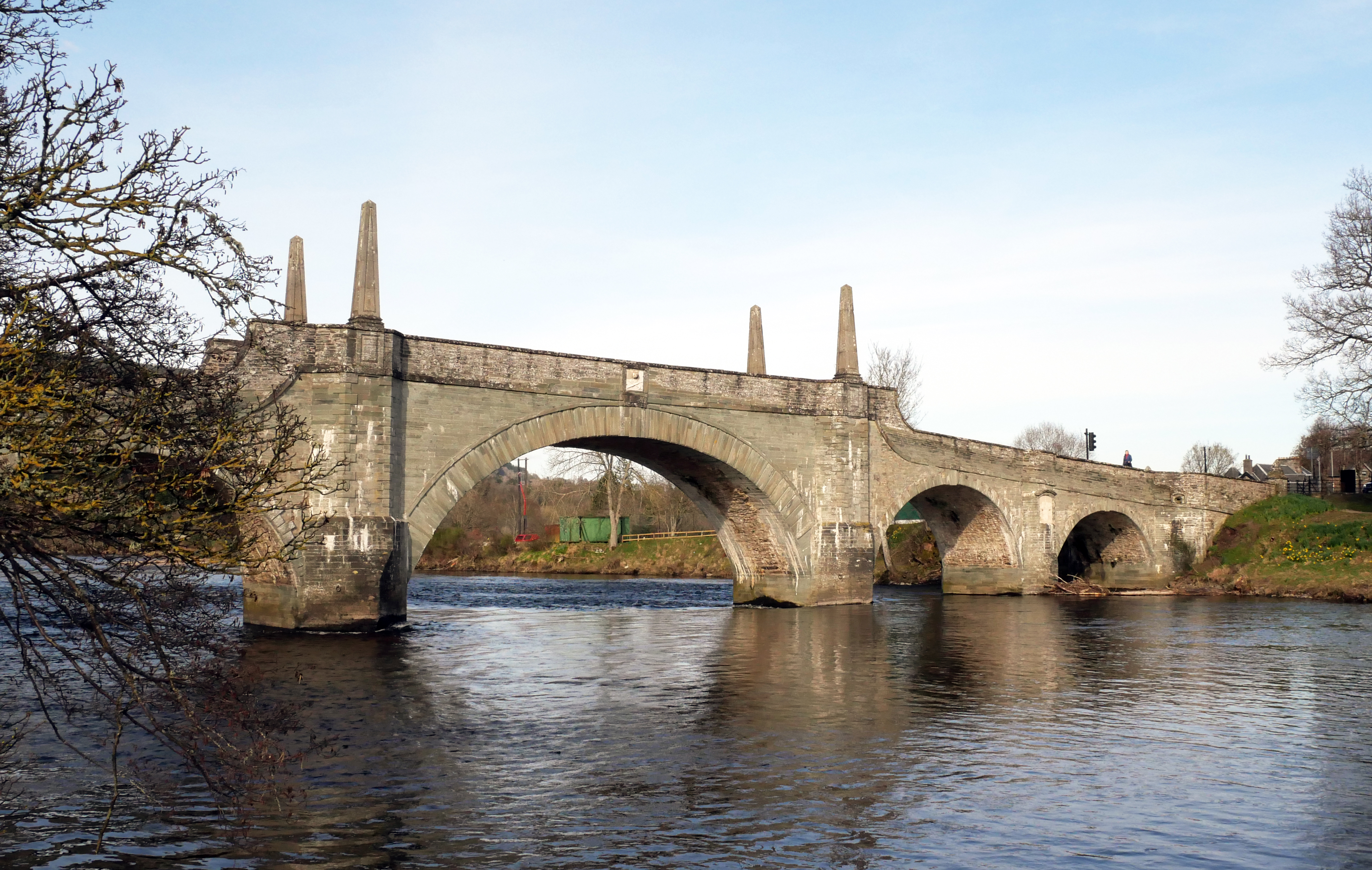
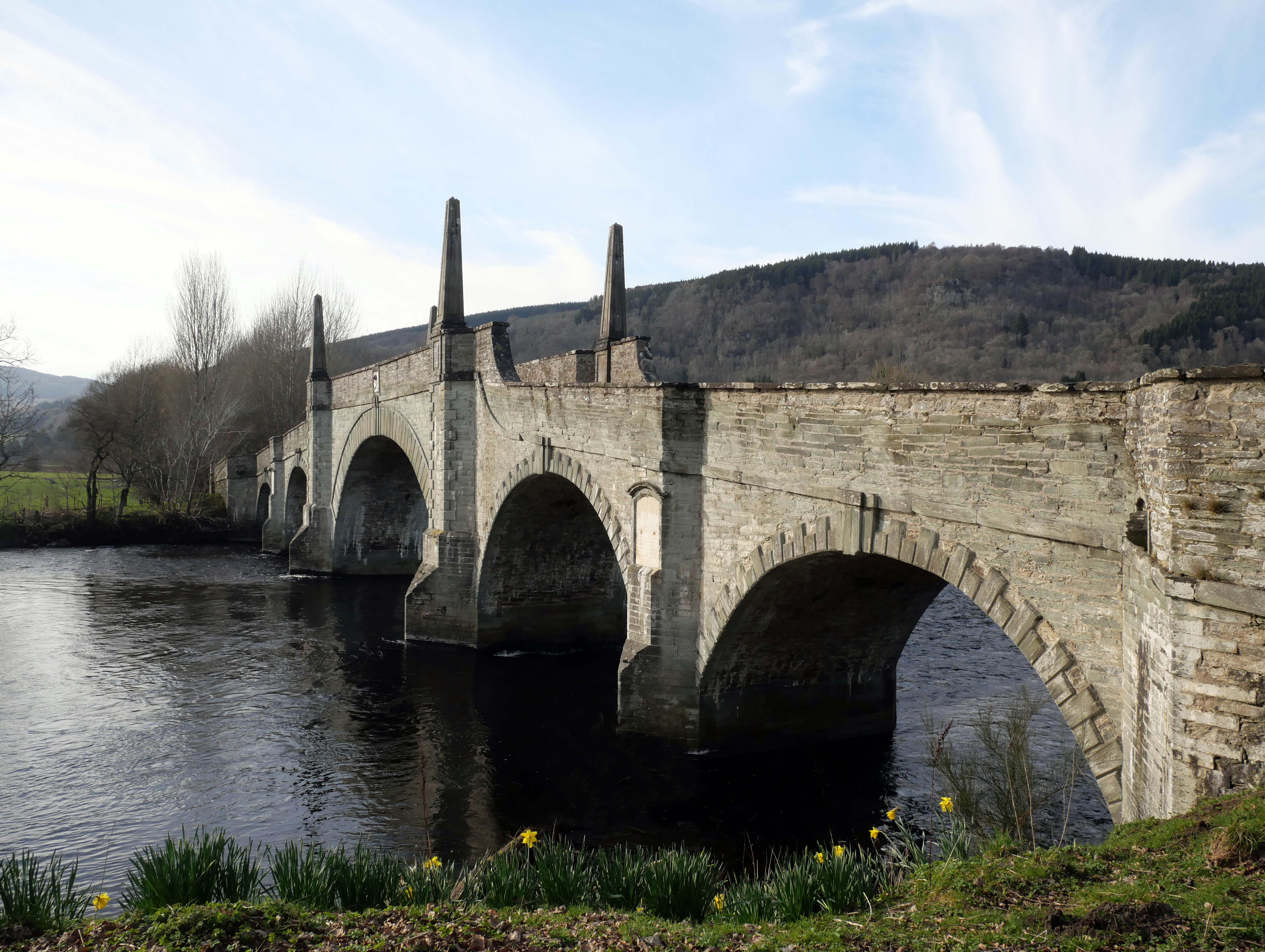
Wade was accustomed to consider Taybridge his masterpiece. In its erection he had the help of William Adam the architect, father of the famous Robert Adam. The whole work, begun in April 1733, was completed in nine months as noted on one of the now badly weathered marble tablets let into the stonework above the piers next to the banks on the upstream aspect and also on the grey stone plaques on the lower, north-east, side. On the completion of the bridge it is said that Wade declared that he had fulfilled his intention of “setting the rapacious ferryman and his boats on dry land!”
The statement on the tablet to the effect that the bridge was completed in nine months is not strictly accurate, for by October 1733 it was built up only to pavement level. Wade was accustomed to knock off all work on his roads and bridges each October and in the case of Taybridge, the parapet, four feet high over the side arches, was not added till the following year.
It was hailed in these days as the finest bridge in Scotland and was at that time, 1733, the only one spanning the Tay; the old Perth bridge which was swept away in 1661 not being rebuilt till 1772. Of peculiar design, described on the one hand by guidebooks as “graceful and elegant” and on the other by Dorothy Wordsworth, sister of the poet, who visited the district in 1803, as of “ambitious and ugly architecture”, it may at least, and without fear of contradiction, be labelled “picturesque”.
Robert Southey in his Journal of a Tour in Scotland, 1819, wrote: “Near Aberfeldy is a bridge over the Tay, built by General Wade, but creditable to neither the skill nor taste of the architect. It resembles that at Blenheim, the middle arch being made the principle feature. At a distance it looks well but makes a wretched appearance upon close inspection. There are four unnecessary obelisks upon the central arch and the parapet is so high you cannot see over it. The foundations are very insecure, for we went into the bed of the river to examine them”.
When he criticises the taste of the architect, one is justified in assuming that he is merely expressing his own opinion, and this need not therefore be taken at more than its worth as such. As regards not being able to see over the parapet, this never applied to any part except that over the central arch; if there is any fault, it is that with successive layings of road metal over a long period of years, the wall over the other four arches is becoming very low, at parts less than 2.5 ft. Finally, one has only to think back over the floods and frosts, storms and stresses, that the bridge has weathered during the past centuries and more to appreciate how utterly wrong he was with regards to the foundations, his statement being all the more remarkable when it is probable that by his use of the pronoun ‘we’ he included with his own opinion that of his fellow traveller, Thomas Telford, the famous bridge builder.

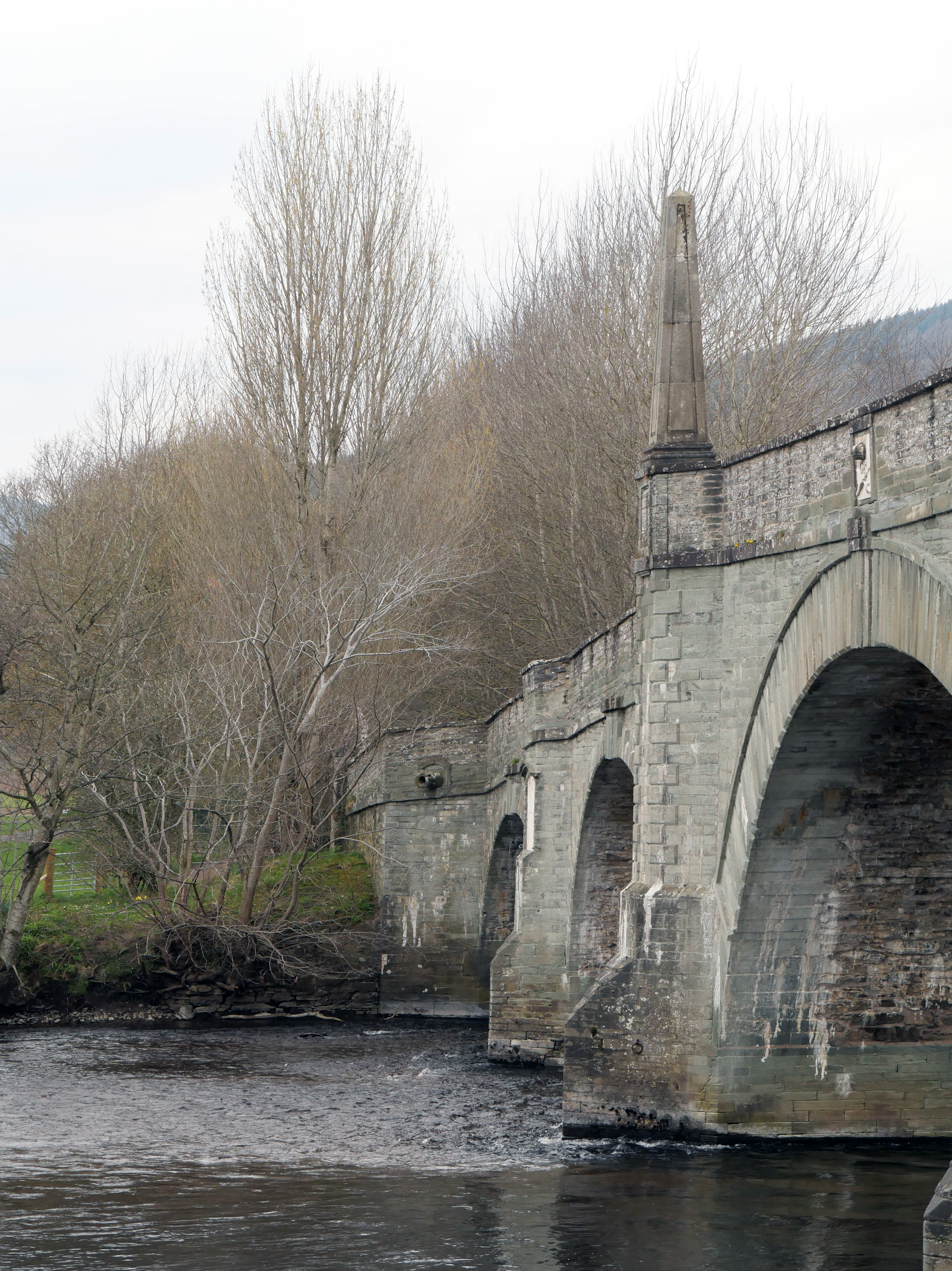
Spanning the river in five arches, the middle one of which covers 60 feet, Taybridge measures in all 370 feet in length. The four obelisks to which Southey took exception – 12 feet above the parapet and about 18 feet above the roadway – which are so marked a feature of the design and which appear in Adam’s plan, were apparently added some time after the work was otherwise complete as in a contemporary picture of the General with the bridge in the background they are wanting.
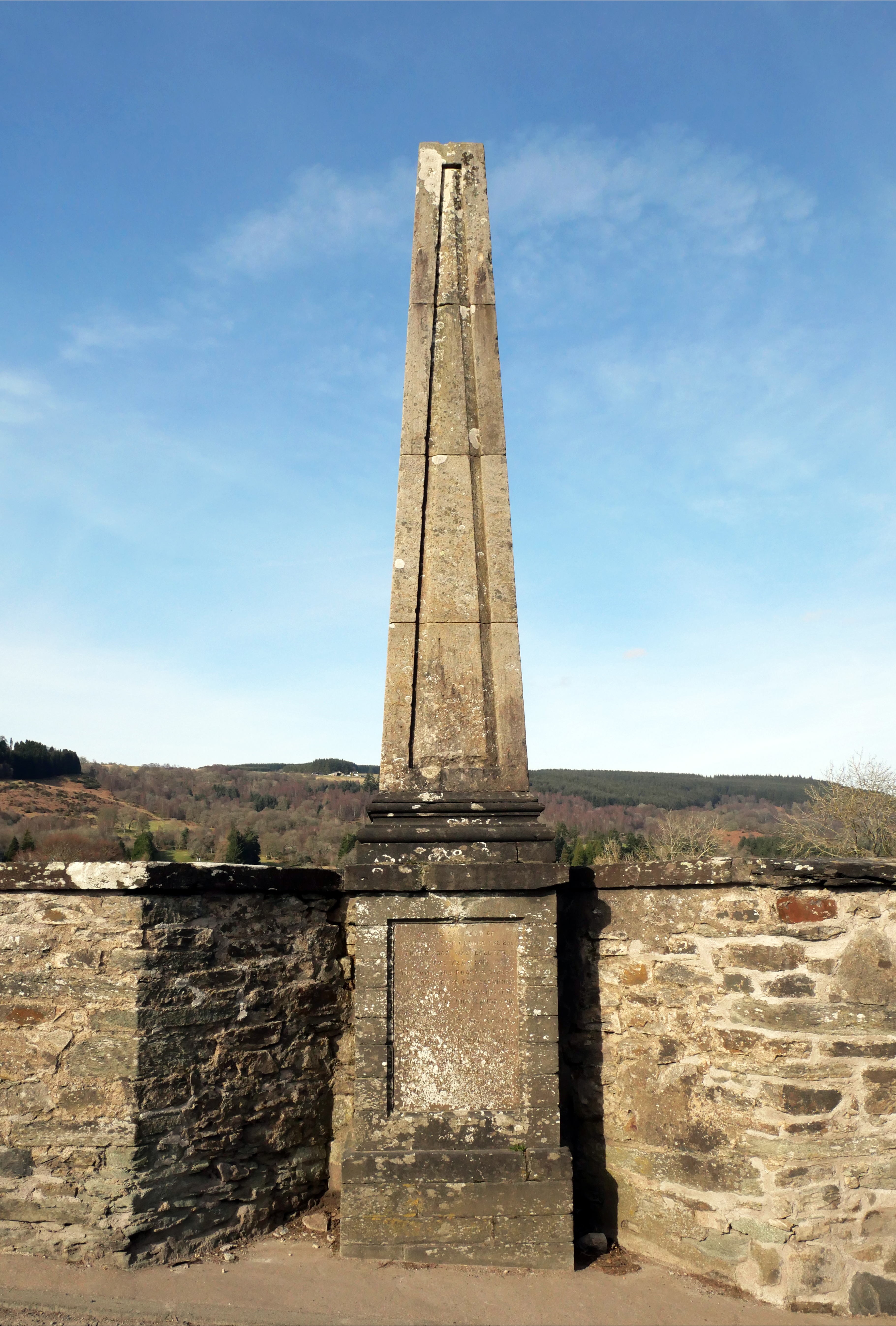
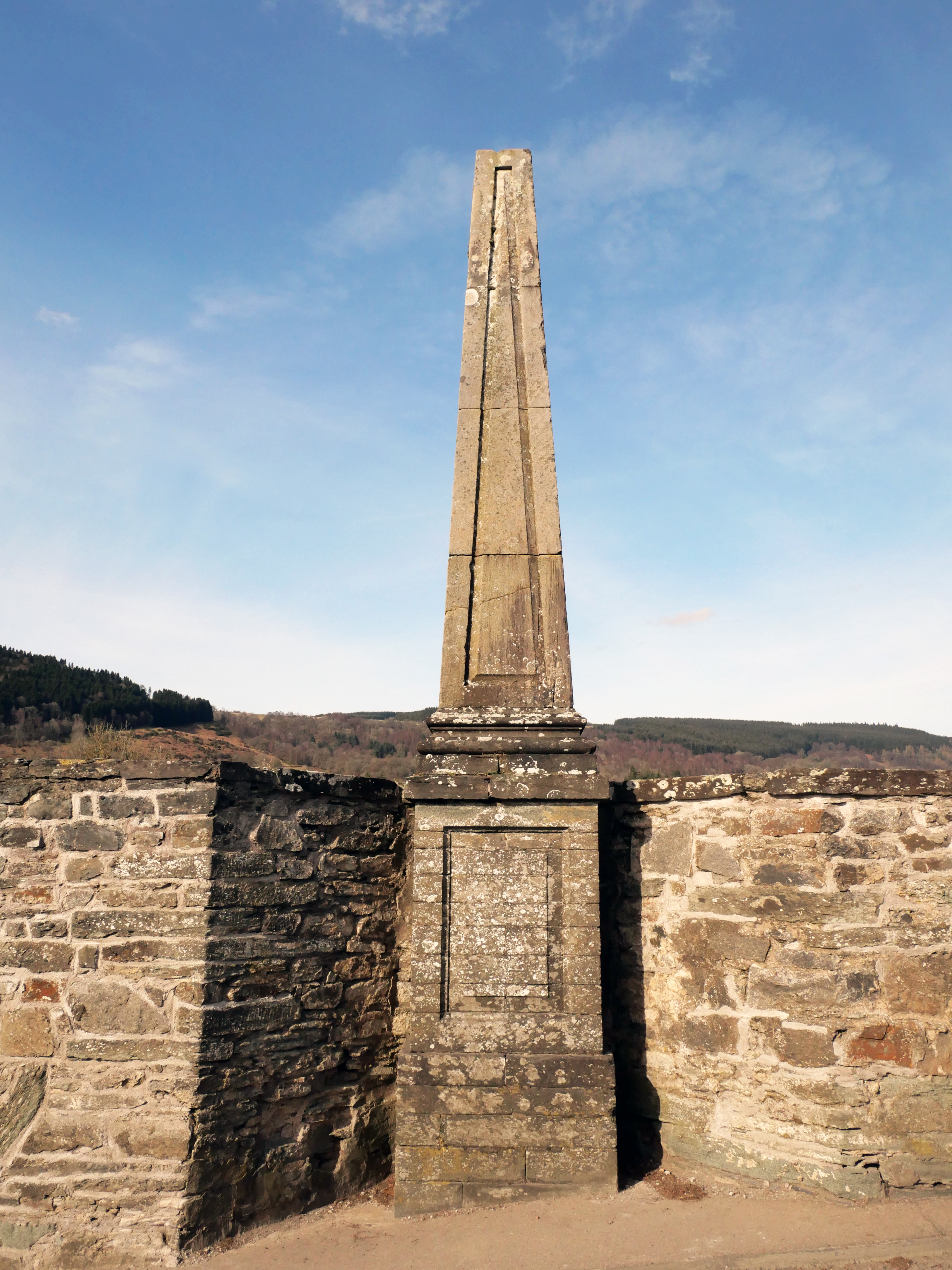
In 1932, two tablets bearing copies of Wade’s original inscriptions were let into the stonework of the plinths of two of the four obelisks, the one on the right as one nears the summit of the rise from Aberfeldy side bearing the English inscription, and that on the right as one comes up from the further bank the Latin. On one occasion in 1954 as Dr. Mackay was crossing the bridge, he noticed two women visitors studying the Latin inscription. First woman, “What does all that mean? “Second woman, “Can’t say. I don’t know Gaelic!”. He could imagine the expression on the face of Dr. Friend, Headmaster of Westminster School and composer of the inscription, had he been privileged to share Dr. Mackay’s experience.
These tablets were unveiled by J. Stewart Robertson, Esq. of Edradynate at a public ceremony held on 17th August, 1932.
Over the keystone of the centre arch, upstream, is a bevelled panel in white marble with the Crown, Sceptre, and Sword; this is repeated in grey stone on the downstream aspect.

Above the small arches on both sides of the bridge, projecting some 2 feet, are beautifully formed small stone cannon of a circumference of about 3 feet and a bore of 7 or 8 inches diameter.
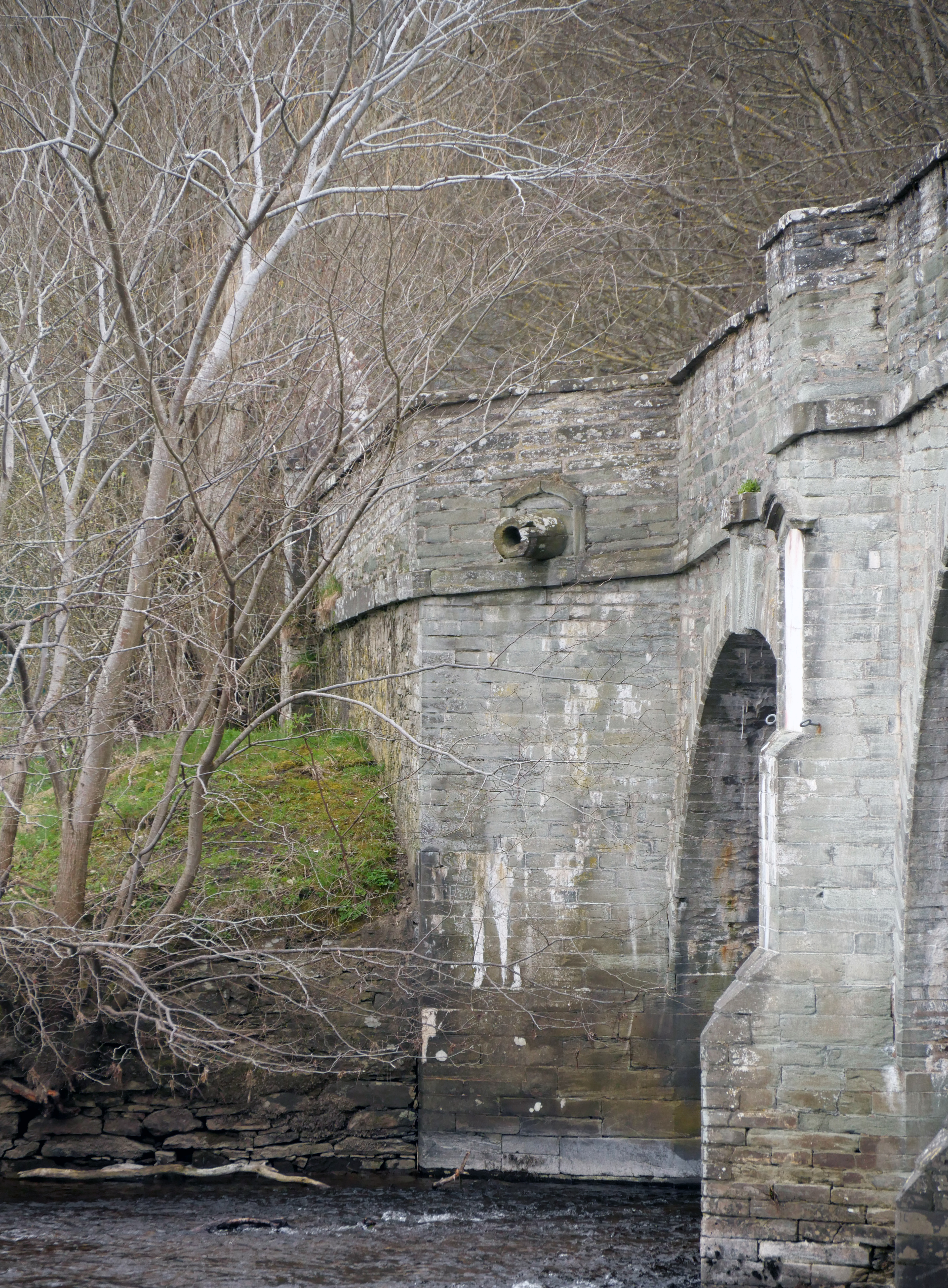


There are hanging iron rings on both piers of the centre arch, upstream one on each side of the two cutwaters, and downstream an equal number in corresponding positions – eight in all. What purpose they were intended to serve is obscure; an enquiry directed to the staff of the Royal Commission on Ancient Monuments elicited the suggestion that they might have been connected with drop-gates, but the fact that they are on both the upstream and downstream sides seems against this. As a boy Dr. Mackay heard it said that they were used in connection with rafting down the river of timber, a practice which was in vogue as late as the middle of the 18th Century, when local timber was mostly used (all of which, by the way, had to be hand dressed). This explanation of their presence is at least not improbable as men in charge of rafts with wood intended for use in Aberfeldy would find in them a convenient means of tying up fore and aft in comparatively deep water.
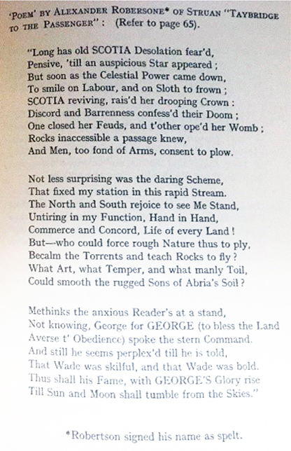
It may be of interest to some to know that the wood which was used in the building operations was given by Alexander Robertson of Struan who, oddly enough, was a bitter Jacobite, and who as such, still more oddly, attended the opening ceremony in 1735 at which General Wade himself was present and laid on the parapet a turgid and rather stupid poem eulogising the General entitled “Taybridge to the Passenger”.
A reporter of that time must have made a copy of the verse for it appeared in The Edinburgh Courant of December 12th of the same year when Struan’s generosity in supplying wood from Rannoch for Edinburgh Infirmary was also noted.
After the building of the bridge was completed, at a cost it may be noted of £4,095 5s 10d, the scaffolding, mainly fir and larch, was dragged by horse labour to the Kirk of Amulree where it was utilised as joists, seats, etc.
The stone used in the construction is chlorite schist from a quarry above Bolfracks (old spelling ‘Bulfrac’ – ‘spotted hut’) from which, later, the stone used in the building of Taymouth was also taken. It was supplied by the Laird of Bolfracks, one of the Menzies, who at that time held the Barony of Bolfracks, and has the advantage of being soft and easily worked when quarried and of hardening on exposure.
Skilled workmen were employed for over two years at Bolfracks; all the stones were hewn, marked and numbered and conveyed to the bridge where they were laid in their respective places, like stones in King Solomon’s Temple, without the sound of a single hammer. The principle stones of the arches appear to have been wrought by the Masonic Guild, who put their mark upon their work.
In the House of Commons Journal, 7th February, 1734, it is stated that “the starlings are of oak, and the piers and landbreasts founded on piles shod with iron”. Below the bridge the river bed is causewayed from side to side to prevent attrition of the waterway and undermining of the arch abutments.
Steep slopes from both approaches lead to the centre of the bridge, where the roadway is very narrow. In December of 1953 temporary traffic lights similar to those used by road working gangs were given a try out and found so successful that permission to set up a permanent installation was sought; the cost was estimated at £200 – £300 with maintenance charge of £30 annually, exclusive of lighting. A traffic census was taken by the County Council, but the matter was turned down by the Ministry of Transport and the Chief Constable. These were eventually installed in the late 1970s and updated in 2022.
Also in 1953, a scale was marked out on which the rise and fall of water could be read out in feet. It was on the cutwater of the pier furthest from, but on the face that slants towards, Aberfeldy. In low water this pier stands almost high and dry on a gravel bank; spawning salmon sometimes use this bank in season and may be observed from the bridge.
Some twelve years after the completion, Taybridge was put to its first big test for, in August 1745, Sir John Cope in his expedition against Prince Charlie with his forces, artillery, baggage waggons and all, passed through Aberfeldy and camped on the north side of the river. It is more than probable that Wade in his building kept in mind the need for a bridge strong enough to stand up to the passage of such artillery and heavy vehicles as were used in his day; indeed it is said that the passing of a train of artillery was the test of strength of the forty or so bridges in his road system, but, if he were to return to this mechanised age and see the traffic it now has to carry, far heavier than any artillery he could have visualised, we are sure he would feel tempted to say, “Truly, I built better than I knew!”
It was in the 219th year of its existence that Taybridge sustained its first real casualty. On 18th December, 1951, some huge metal castings that were being transported by road for use in the construction of a hydro-electric station further west, though too wide to pass, were forced through and, after scoring both parapets, hit the shoulder of the high parapet beyond the obelisk furthest from the town and downstream knocking away the flat coping stones and part of the wall beneath, effectually rounding off the angle; at the same time the coping stones on the parapet opposite were loosened and considerably splintered.
In 1746 Prince Charlie, retiring northwards before the advance of the Duke of Cumberland, ‘Butcher Cumberland,’ crossed Taybridge with the Highlander part of his army. Cumberland, fearing that the Jacobites might again strike south, sent 200 men to garrison Castle Menzies and a detachment of Hessians to guard the bridge, the latter being quartered in an inn nearby. Sir Robert Menzies, though a staunch Hanovarian, was turned out at a moment’s notice and was forced to find accommodation in a neighbouring cottage. Later, he put in a claim, indorsed 1750, for £1000 and “humble hopes that his Majesty will be gratiously please to order remede” against damage resulting from the occupation of the castle and furniture rendered useless by the “outbreak of an epidemical fever among the troops”.
When it is recalled that the oldest house in Aberfeldy, Moness was not built till 1753, it brings home to us the fact, surely worthy of thought, that of the various hamlets, etc., which stood here in Wade’s time, not one solitary house remains.
The view westwards from the bridge however is still just as he must have seen it – the broad stream divided by the tree-clad island in the foreground, the hill slopes sweeping upwards on either hand, the bold cliffs of Weem rock to the North, and in the distance the lofty mountain guarding the entrance to Glenlyon, and the still higher summits of the Ben Lawers’ spur of the Grampians culminating in Ben Lawers (3984 feet) itself – surely a vista of natural beauty calculated to stir the blasé and satisfy the fastidious.
More prosaically it may be noted that the Tay, 110 miles from its source 3,000 feet up on Ben Lui (Beinn Laoigh) to the sea, is the longest river in Scotland, that it carries down with it more water than any other river in Britain, and that in its name we have preserved that of Celtic river goddess, in Gaelic ‘Tatha’, ‘the Silent One’ – in Ptolemy’s Notes, ‘Tava’, in Devon the ‘Tavy’ and the ‘Taw’, and in Wales the ‘Tawe’.
References:
Information here has come from Dr. N. D. Mackay’s book ‘Aberfeldy Past and Present’ and Cameron’s Guide Book ‘Aberfeldy and the Neighbourhood’.
For information on the individual Heritage Trail locations, click on these links:
00: A brief history of the Churches in the Aberfeldy area; 01: The Square; 02: Aberfeldy Town Hall;
03: Former St. Andrew’s Church; 04: Birks of Aberfeldy; 05: Moness House; 06: Aberfeldy Hospitals;
07: Former Wee Free Chapel; 08: Independent Chapel; 09: The Watermill; 10: Parish Church;
11: Breadalbane Academy; 12: St. Margaret’s Church; 13: Black Watch memorial; 14: Aberfeldy Golf Club;
15: Wade’s Bridge; 16: Weem Parish Church; 17: Menzies Mausoleum; 18a Castle Menzies;
18b Castle Menzies Walled Garden; 19: Our Lady of Mercy’s RC Church; 20: Aberfeldy Branch Line.

You must be logged in to post a comment.