The Royal Commission on the Ancient and Historical Monuments of Scotland (RCAHMS) has a record of a single standing stone, Tom-an-Droighne, in the grounds of Killiechassie, which is noted in Mackay’s “Aberfeldy Past and Present” published in 1954. He believed this was the only sign of an earlier chapel and burying ground within the Killiechassie grounds (Killiechassie – “the church of the steep face”).
The stone was resurveyed in February 1975 “At NN 8716 5094, a squarish earthfast block in a false crest position. It measures 1.0m high x 0.7m square at base. Despite its small size, there is nothing to indicate that it is not of ancient origin”.
For details of the above, refer to the RCAHMS references noted below
Whether or not this standing stone represents an earlier burial site, Breadalbane Heritage Society’s interest lies within the current burial ground on the south side of the Weem to Strathtay road.
| 1727 | Rev. Robert Stewart’s will dated 7th October directs his wife “to bestow the sum of 500 merks Scots money towards the building of the Chapell of Killiechassie”. (Reference: “Historic Memorials of The Stewarts of Forthergill” by Charles Poyntz Stewart, 1879). |
| 1729 | Rev. Robert Stewart died and “his body was gently borne, shoulder high, by his parishioners to Killiechassie, a distance of twenty-four miles, and interred in the chapel there, which has ever since continued to be the family burying-place of his descendants”. (Reference: “Historic Memorials of The Stewarts of Forthergill” by Charles Poyntz Stewart, 1879). |
| Jan 1730 | The will of Anna Campbell, widow of Rev. Robert Stewart, declares that “my body to be decently buried in the Chappell of Killiechassie” and that her sons are to “finish the Chappell at Killiechassie to the sight and to the satisfaction of Mr James Stewart, Minister of Moulin, and James Menzies of Culdariss”. |
| 1747 | Roy’s Military Map shows a ‘Chapel’ near the current location of Killiechassie, although no place names are given on the map. |
| 1755 | Stobie’s Map shows ‘Killiechassie’ and ‘Chapelton’ but is folded where the Chapel may have been. |
| 1775 | Stobie’s Map shows only estate houses and names. |
| 1787 | A Plan of the Lands of Killiechassie, by the surveyor Robert Robertson, shows a ‘Chaple’ on the south of the Weem to Logierait road on the site of the current graveyard. Also shown on the north side of the toll road opposite the Chaple are several houses annotated as Chapeltown. |
| 1832 | Thomson’s map shows ‘Killiechassie’ and ‘Chapelton’ and an unnamed building in the position where the current graveyard is situated. The chapel on the hillside has disappeared. |
| 1854 | Sale documents of the Killiechassie estate in 1854 state “now enclosed by a stone wall and surrounded by trees” |
| 1862 | On the Ordnance Survey First Edition map, the unnamed building is shown as ‘Mausoleum’, in the location of the current graveyard (a building within a small walled enclosure). There is no access path from the road. It is likely that the original Chapel and burial ground were erected in 1729 on the site of the current graveyard; by 1862 the chapel had collapsed leaving only a graveyard. |
| 1865 | A post 1865 Map (including the Aberfeldy branch railway line) shows the same as 1862 |
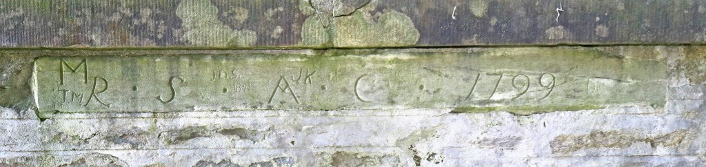
| 1884 | A large memorial stone is erected on the north side of the burial ground by James Stewart-Robertson of Edradynate. It is likely that the graveyard as we see it today was laid out at this time on the site of the original chapel. On the outside of the north wall of the Burial Ground, facing north, there is a lintel stone bearing the inscription: “R S A C 1729” which is the only remnant of the chapel. The five recumbent stones may have been laid at this time, but the upright stone (Adam Stewart) is a different style and may have already been incorporated in the west wall or may have been moved from elsewhere. |
| 1900 | OS County Series 1st Edition map shows the Mausoleum and, for the first time, the access path from the Weem to Logierait road (which may have been created in 1884). |
| 1946 | An aerial photograph of Killiechassie shows the enclosure, very overgrown with tall trees around the external circumference. |
| 1990s | Volunteers from Breadalbane Heritage Society cleared the site and for the next few years ensured that the grass was cut and moss removed from the stonework on a regular basis, in order to keep the site tidy and safe. |
| 2011 | Anne Beeson, on behalf of Breadalbane Heritage Society, undertook a great deal of research into the history of the graveyard and its ownership, confirming with Duncan Thomson of J & H Mitchell, Solicitors, that the Burial Ground no longer had a “legal owner”. Michael Campbell, current owner of Edradynate, agreed to try to raise funds to pay for remedial work and upkeep at the Burial Ground by approaching other owners/occupiers of the Strathtay estates which featured in the history of the graveyard (i.e. estates that formerly comprised Killiechassie). Sufficient money was raised to create an endowment which would provide funds from income to pay for such works in perpetuity. Michael Campbell also contacted the surviving descendants of James Stewart-Robertson of Edradynate (* Jamie Stewart-Meiklejohn) and Anne Beeson subsequently obtained consent for the Breadalbane Heritage Society to maintain and preserve the Burial Ground. |
| 2012 | Sufficient funding was immediately available to repair the wall of the enclosure and the entrance step. Some large trees were removed. Other funding sources were sought (Griffin Wind Farm Community Fund) and timber covers were erected over the five recumbent gravestones to protect them from further weather damage. Over the next few years minimal maintenance was undertaken. |
| 2019 | Breadalbane Heritage Society resumed a programme of regular maintenance of the grounds. |
From the evidence of maps and plans, and the texts of several Instruments of Sasine recording sales of Killiechassie in the 19th century, the Chapel of Killiechassie which Rev. Robert Stewart directed his wife to build, was erected on the site of the current burial ground. The only evidence of it now visible is the lintel stone bearing the initials of Robert Stewart and Anne Campbell.
References:
RCAHMS Records for sites at Killiechassie
Site type: STANDING STONE
Canmore ID: 25725
Site Number: NN85SE 7
NGR: NN 8716 5094
Council: PERTH AND KINROSS
Parish: WEEM
Archaeological Notes
NN85SE 7 8716 5094.
(NN 8710 5100): Standing Stone. Information from M E C Stewart, 14 December 1964.
At NN 8716 5094, a squarish, earthfast block in a false crest position. It measures 1.0m high x 0.7m square at base. Despite its small size, there is nothing to indicate that it is not of ancient origin.
Surveyed at 1:2500. Visited and resurveyed by OS (AA) 12 February 1975.
***********
Site type: NATURAL FEATURE
Canmore ID: 25712
Site Number: NN85SE 32
NGR: NN 8685 5124
Council: PERTH AND KINROSS
Parish: WEEM
Archaeological Notes
NN 869 512: Carn Mor (Big Cairn) is situated near the NE boundary of Killiechassie estate near a tinkers’ winter camp. J Kennedy 1927
NN 8685 5124: Carn Mor refers to a rocky crag. There is no evidence of a cairn in the area.
Visited and resurveyed by OS (RD) 10 February 1971
In “Folklore and Reminiscences of Strathtay and Grandtully”, published in 1927, James Kennedy rerfers to a large cairn near the boundary of the Killiechassie estate. This is almost certainly the Carn Mor surveyed by RCAHMS.
In Mackay’s “Aberfeldy Past and Present”, published in 1954, there is a reference to “a single standing stone” which he believed to be the only sign of the original chapel and burial ground. This is almost certainly the remnant of a much older building surveyed by RCAHMS.
RCAHMS have two records for items in the Killiechassie grounds. The first is for a Standing Stone, information on which was povided by Dr. Margaret E. C. Stewart. It was resurveyed in 1971.
Links to other KBG pages:
The Stewarts: Lineage of the Stewarts of Fothergill
The Estate: Timeline for the ownership of Killiechassie Estate

You must be logged in to post a comment.